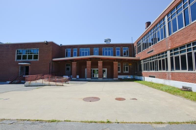
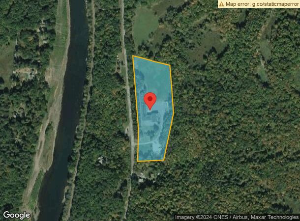
Property Record
10497 State Route 97, Fremont Center, NY 12736
NEARBY LISTINGS FOR SALE OR LEASE
-
-
View all Fremont Center listings for sale on LoopNet.com
Property Detail
10497 State Route 97
Publicschool
Sullivan
X
New York
42127C0140D
27.001
2024
10.92 AC
2023
Hudson Valley Area
950300
Other Market Areas
5,330 SF
3200-037-0-0001-027-001
DEMOGRAPHICS near 10497 State Route 97
1 Mile
3 Mile
5 Mile
2024 Total Population
87
1,079
2,644
2029 Population
89
1,091
2,679
Pop Growth 2024-2029
+ 2.30%
+ 1.11%
+ 1.32%
Average Age
47
46
46
2024 Total Households
38
462
1,148
HH Growth 2024-2029
+ 2.63%
+ 1.30%
+ 1.39%
Median Household Inc
$56,249
$61,172
$61,831
Avg Household Size
2.20
2.10
2.20
2024 Avg HH Vehicles
2.00
2.00
2.00
Median Home Value
$266,666
$220,149
$229,888
Median Year Built
1976
1968
1972
Nearby Places
- Restaurants
- Banks
- Shops
- Fitness
- Groceries
SALE & LEASE HISTORY
LISTING DATE
SALE/LEASE

Sep 30, 2022
For Sale
Sep 26, 2017
For Sale
Mar 29, 2022
For Sale
Jun 13, 2022
For Sale
Nearby Properties
Address
Land Use
TOTAL SIZE
Lot Size
Zoning
Address
Land Use
TOTAL SIZE
Lot Size
Zoning
20,120 SF
48.69 AC
06 - INDUS
Address
Land Use
TOTAL SIZE
Lot Size
Zoning
2,825 SF
127.72 AC
06 - INDUS
Address
Land Use
TOTAL SIZE
Lot Size
Zoning
59.91 AC
06 - INDUS
Address
Land Use
TOTAL SIZE
Lot Size
Zoning
3.89 AC
Address
Land Use
TOTAL SIZE
Lot Size
Zoning
1,264 SF
89.39 AC
Address
Land Use
TOTAL SIZE
Lot Size
Zoning
5,115 SF
0.50 AC
06 - INDUS
Address
Land Use
TOTAL SIZE
Lot Size
Zoning
2,284 SF
13.15 AC
Address
Land Use
TOTAL SIZE
Lot Size
Zoning
2,166 SF
67.04 AC
04 - FARM
Address
Land Use
TOTAL SIZE
Lot Size
Zoning
2,960 SF
4.24 AC
04 - FARM
Address
Land Use
TOTAL SIZE
Lot Size
Zoning
4,536 SF
0.29 AC
05 - COMME
Address
Land Use
TOTAL SIZE
Lot Size
Zoning
1,405 SF
90 AC
04 - FARM
Address
Land Use
TOTAL SIZE
Lot Size
Zoning
3,300 SF
161 AC
04 - FARM
Address
Land Use
TOTAL SIZE
Lot Size
Zoning
17,296 SF
0.89 AC
03 - MULTI
Address
Land Use
TOTAL SIZE
Lot Size
Zoning
7,643 SF
0.83 AC
06 - INDUS
Address
Land Use
TOTAL SIZE
Lot Size
Zoning
1,781 SF
48.79 AC
LC 1
Address
Land Use
TOTAL SIZE
Lot Size
Zoning
11,137 SF
0.51 AC
06 - INDUS
Address
Land Use
TOTAL SIZE
Lot Size
Zoning
87.82 AC
04 - FARM
Address
Land Use
TOTAL SIZE
Lot Size
Zoning
1,251 SF
143 AC
Address
Land Use
TOTAL SIZE
Lot Size
Zoning
1,743 SF
30 AC
04 - FARM
Address
Land Use
TOTAL SIZE
Lot Size
Zoning
1,596 SF
60.10 AC
04 - FARM
Address
Land Use
TOTAL SIZE
Lot Size
Zoning
4,830 SF
0.34 AC
05 - COMME
Address
Land Use
TOTAL SIZE
Lot Size
Zoning
6,636 SF
0.24 AC
06 - INDUS
Address
Land Use
TOTAL SIZE
Lot Size
Zoning
2,184 SF
2.19 AC
04 - FARM
Address
Land Use
TOTAL SIZE
Lot Size
Zoning
4,200 SF
1.45 AC
06 - INDUS
Address
Land Use
TOTAL SIZE
Lot Size
Zoning
5,140 SF
0.21 AC
06 - INDUS
Address
Land Use
TOTAL SIZE
Lot Size
Zoning
3,558 SF
0.15 AC
06 - INDUS
Address
Land Use
TOTAL SIZE
Lot Size
Zoning
0.90 AC
04 - FARM
Address
Land Use
TOTAL SIZE
Lot Size
Zoning
181.70 AC
04 - FARM
Address
Land Use
TOTAL SIZE
Lot Size
Zoning
5,598 SF
0.22 AC
06 - INDUS
The World's #1 Commercial Real Estate Marketplace
Connect with us
© 2025 CoStar Group
The information above has been obtained from sources believed reliable. While we do not doubt its accuracy we have not verified it and make no guarantee, warranty or representation about it. It is your responsibility to independently confirm its accuracy and completeness. Any projections, opinions, assumptions, or estimates used are for example only and do not represent the current or future performance of the property. The value of this transaction to you depends on tax and other factors which should be evaluated by your tax, financial, and legal advisors. You and your advisors should conduct a careful, independent investigation of the property to determine to your satisfaction the suitability of the property for your needs.